Saturday, December 19, 2015

Trouvelot Astronomical Drawings, 19th C

Étienne Léopold Trouvelot was born on 26 Dec 1827 in Guyencourt, France. As a young man he dabbled in politics, becoming a staunch Republican. After Louis Napoleon’s coup in 1852 he fled to America with with his wife Adelaide and settled in Medford, just outside of Boston. He listed his occupation as lithographer.

Although an artist Trouvelot had a keen interest in science and turned his attentions toward sericulture. Hoping to become rich in the American silk trade 
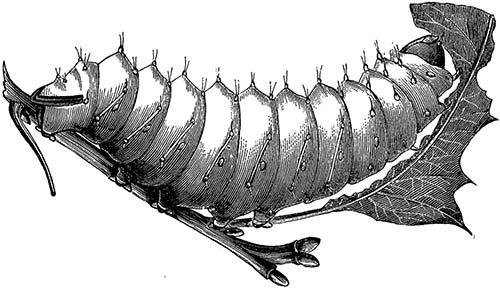
he raised giant silk moths (Antheraea polyphemus), eventually having as many as a million larvae under nets on his five acre property in what he called his “infant industry.”
The American silkworm, click for larger image
Trouvelot, the American Silk Worm, 1867 

In Mar 1867 he returned from France with live gypsy moth (Lymantria dispar) eggs, intending to cross the two moths to develop a disease resistant strain. It would turn out to be a bad idea; not only are gypsy moths and giant silk moths two entirely different species but sometime around 1868-69 some of the moths escaped his nets. He had – quite inadvertantly – introduced the gypsy moth to North America. He knew enough at the time to become alarmed, but after contacting other entomologists there was apparently little concern.

The gypsy moth incident was the beginning of the end of his interest in entomology. In 1870, after observing the aurora, he embarked on his next scientific obsession – astromony. He bought a 6-inch telescope and began preparing drawings that caught the attention of Joseph Winlock who invited him to use the 15-inch Great Refractor at the Harvard College Observatory. His work under the especially clear skies at Cambridge set a new standard for astronomical illustration that wouldn’t be surpassed until the perfection of the photographic dry-plate. In 1872 The New York Times wrote “a person entirely ignorant of astronomy could not fail to be much impressed with [Trouvelot’s] drawings.” Here are a few examples from the 1876 Harvard Annals

Moon Craters, click for larger image Sun Spots, click for larger image
Jupiter, click for larger image
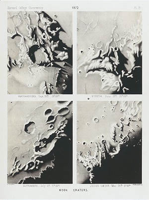
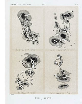
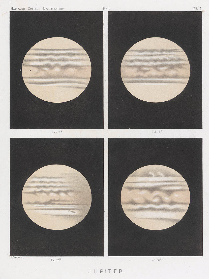
Harvard University Library

In 1875 Trouvelot was invited to the US Naval Observatory to continue his work using the 26-in Great Equatorial, then the largest telescope in the world. As part of the observatory’s exhibit at the 1876 Centennial Exhibition in Philadelphia he prepared a series of large-format pastel illustrations:

Centennial Exhibition, click for larger image

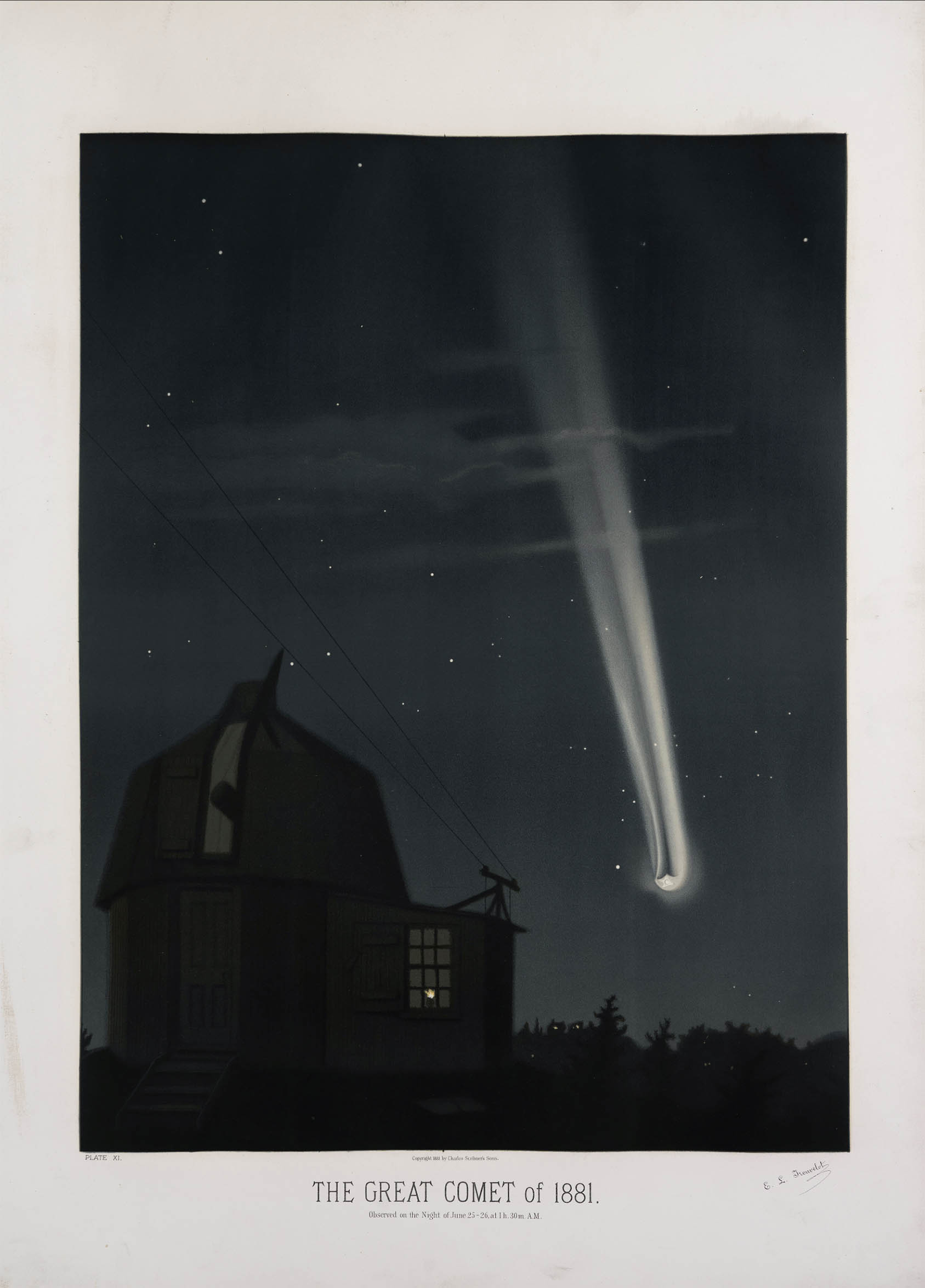
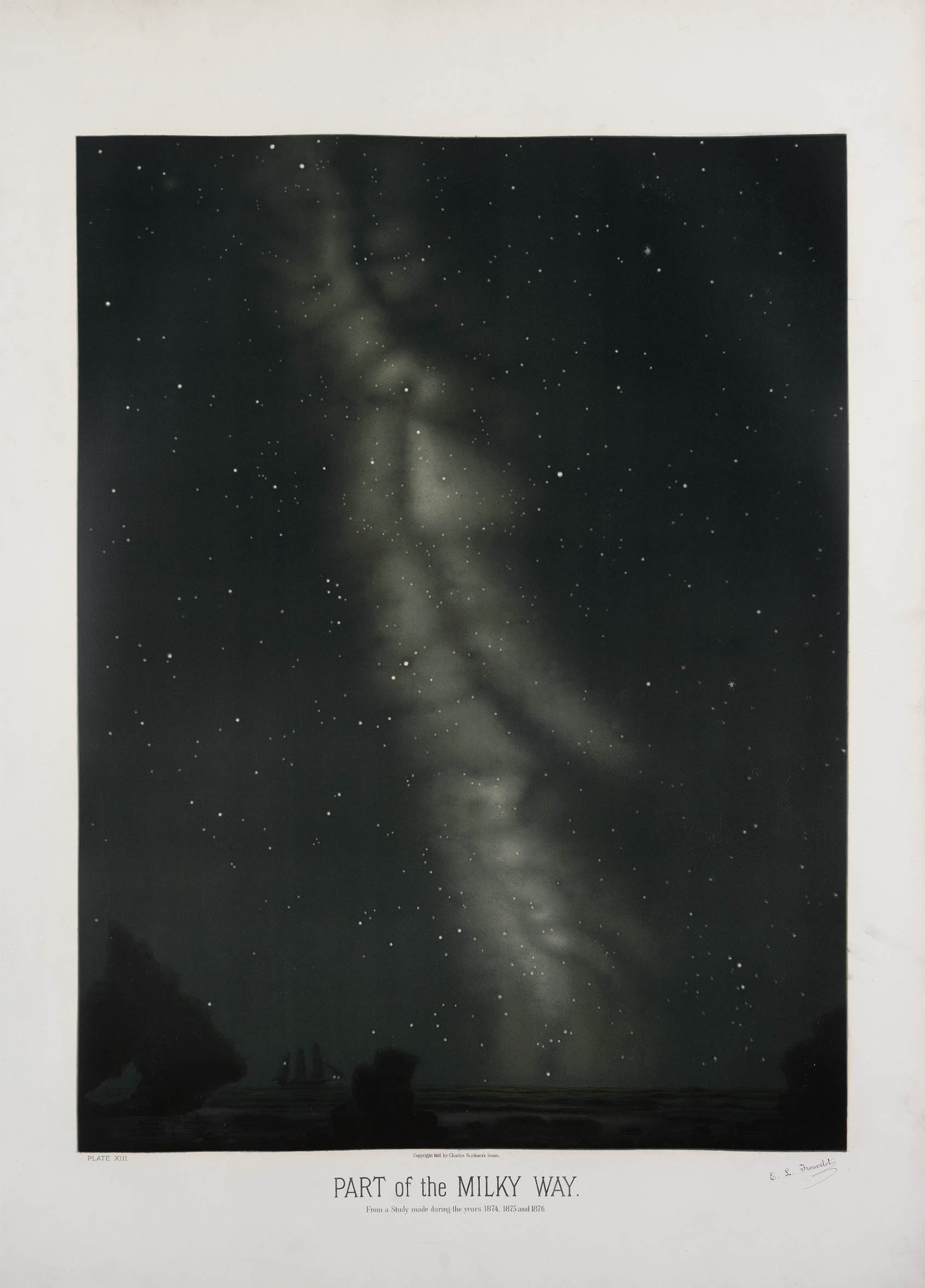
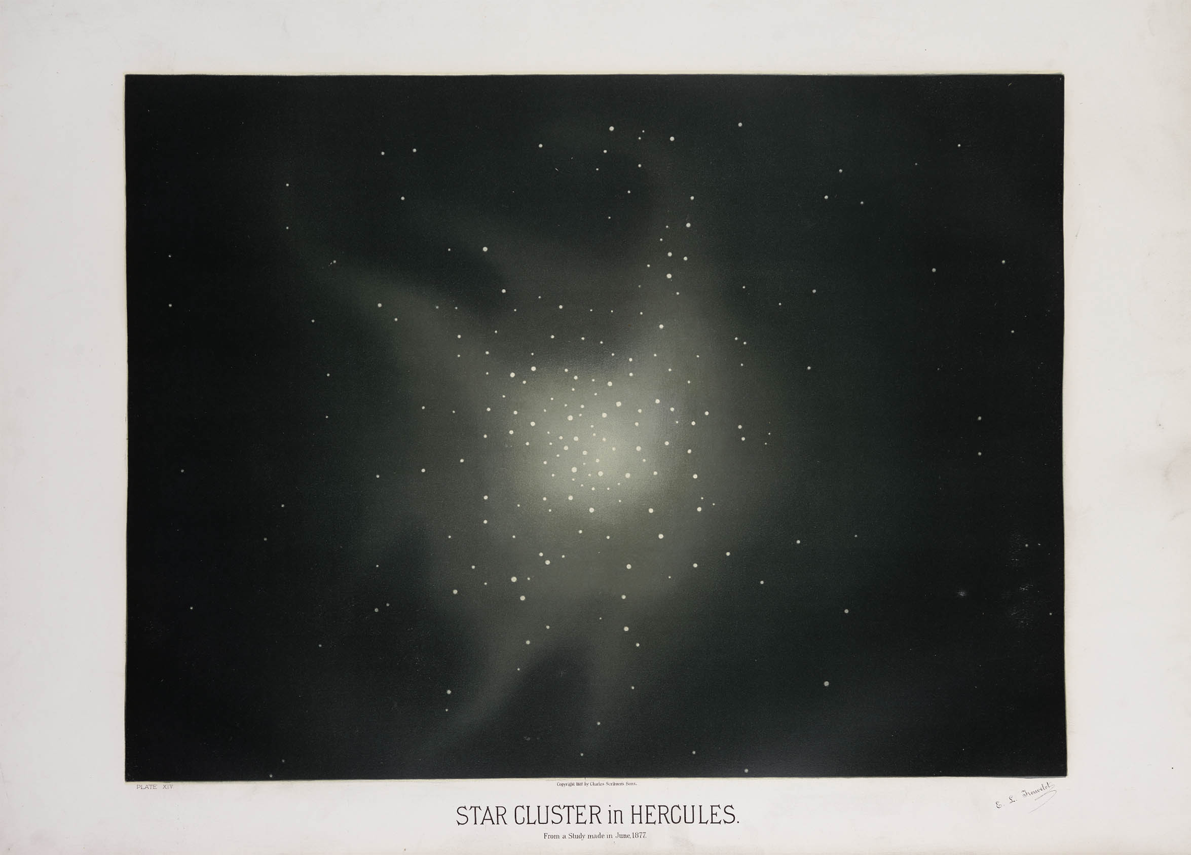
In the late 1870s Trouvelot approached Scribners, who had recent experiance with color lithography, to publish some of his illustrations. He personally supervised the conversion of his pastels into lithographic stones by Armstrong and Co. of Boston. A folio of 15 large-format (24 × 38") chromolithographs and 167-page descriptive manual was published in 1882 as The Trouvelot Astronomical Drawings.5 Despite its small edition size (~300) and its rather prohibitive price of 125 USD, Scribners listed it as one of their most successful titles of the period.

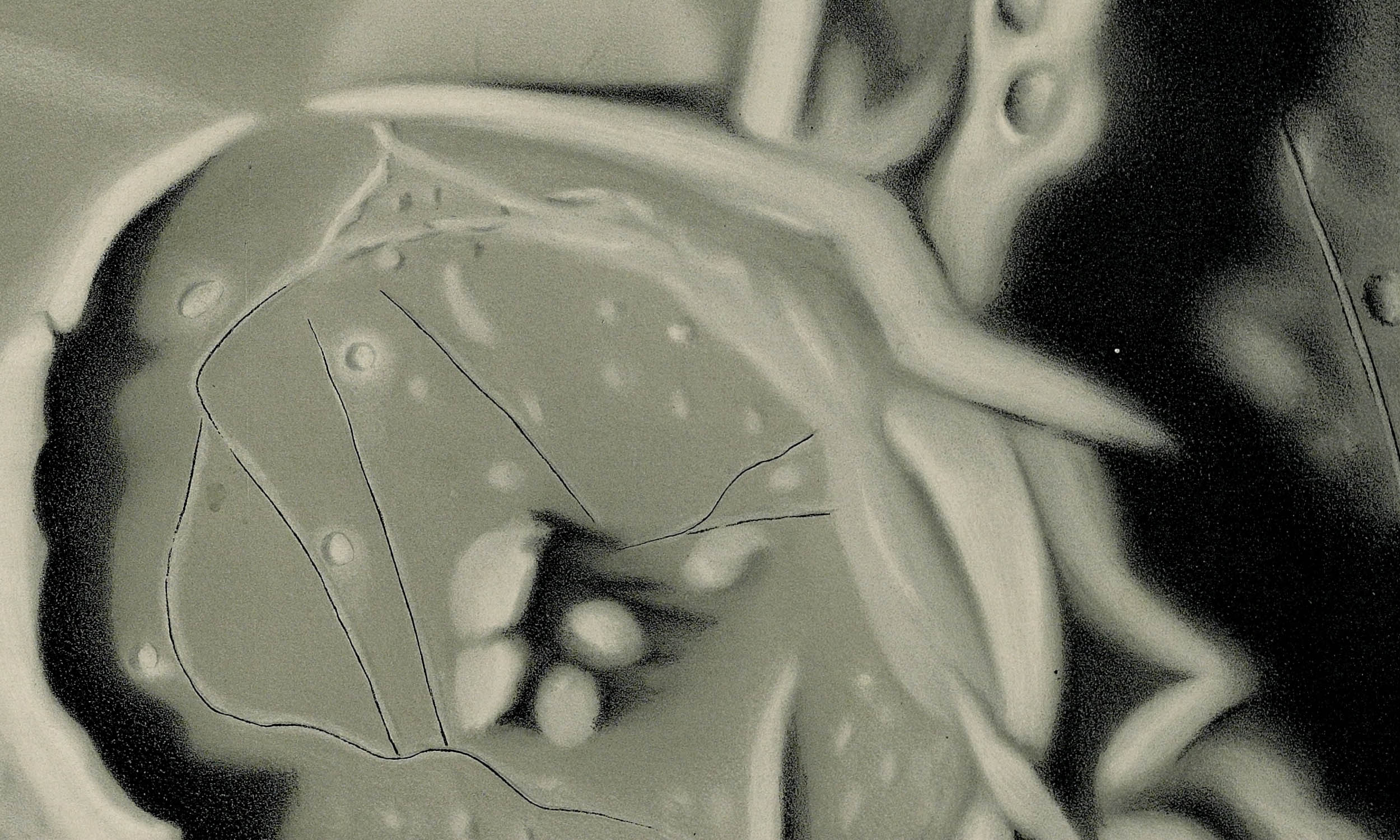
Here is a detail showing the chromolithographic process:

Detail, plate VI, click for larger image

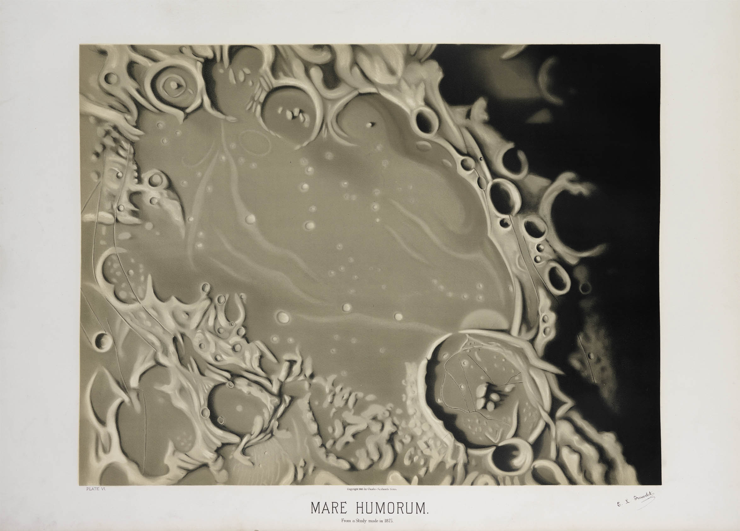
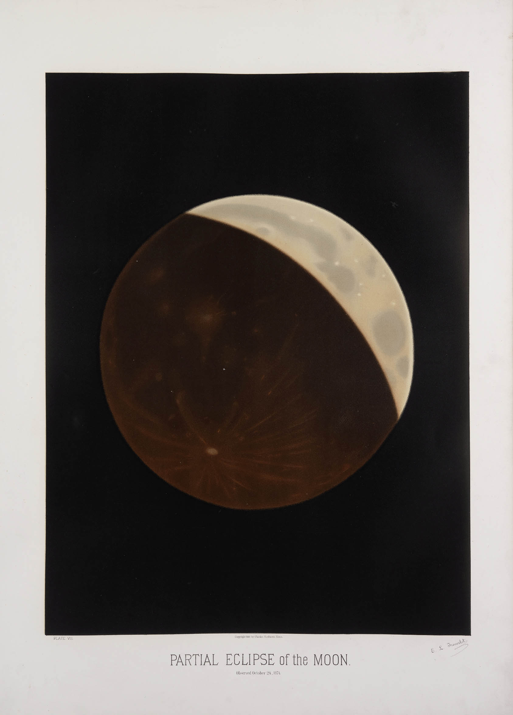
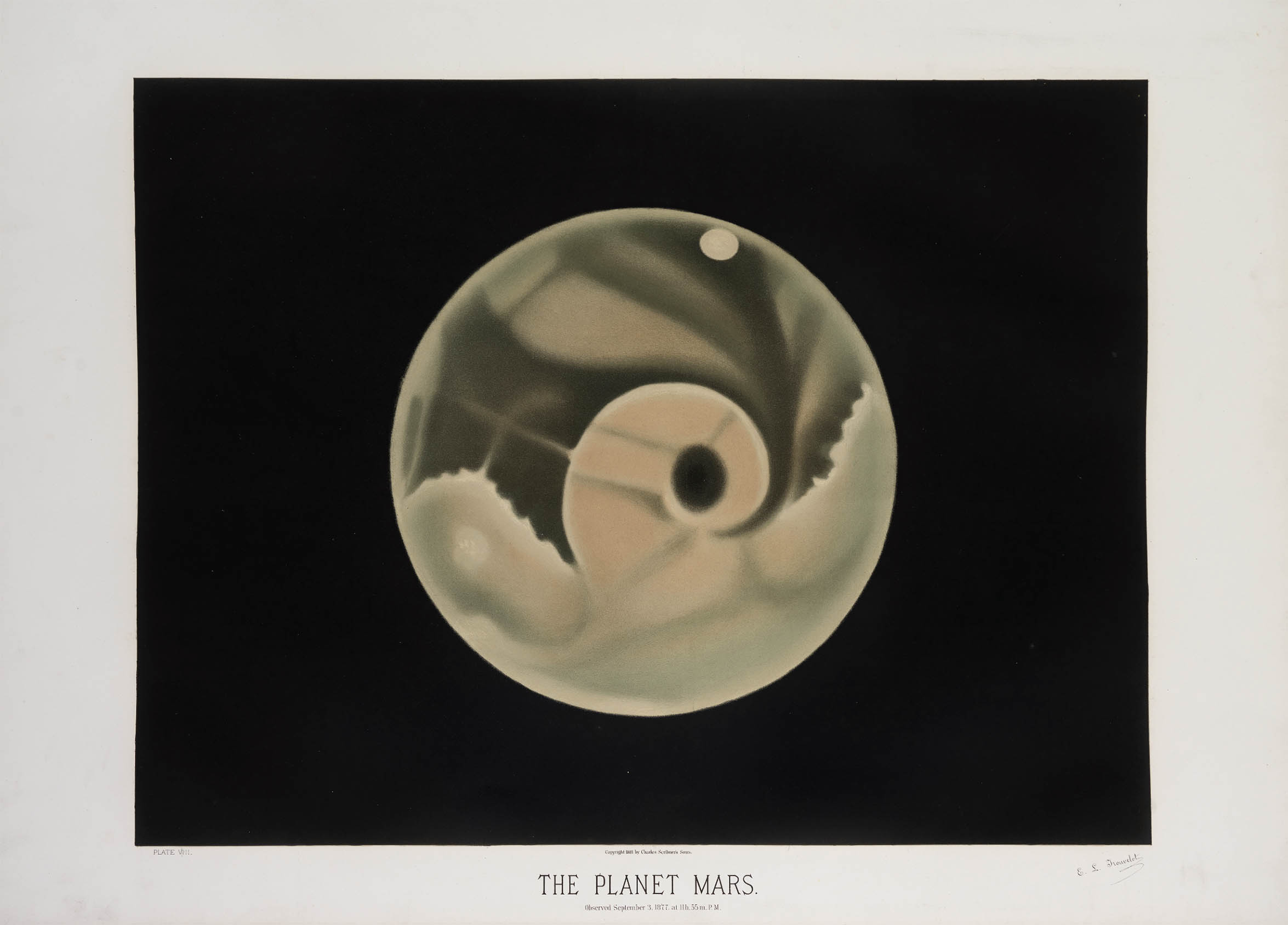
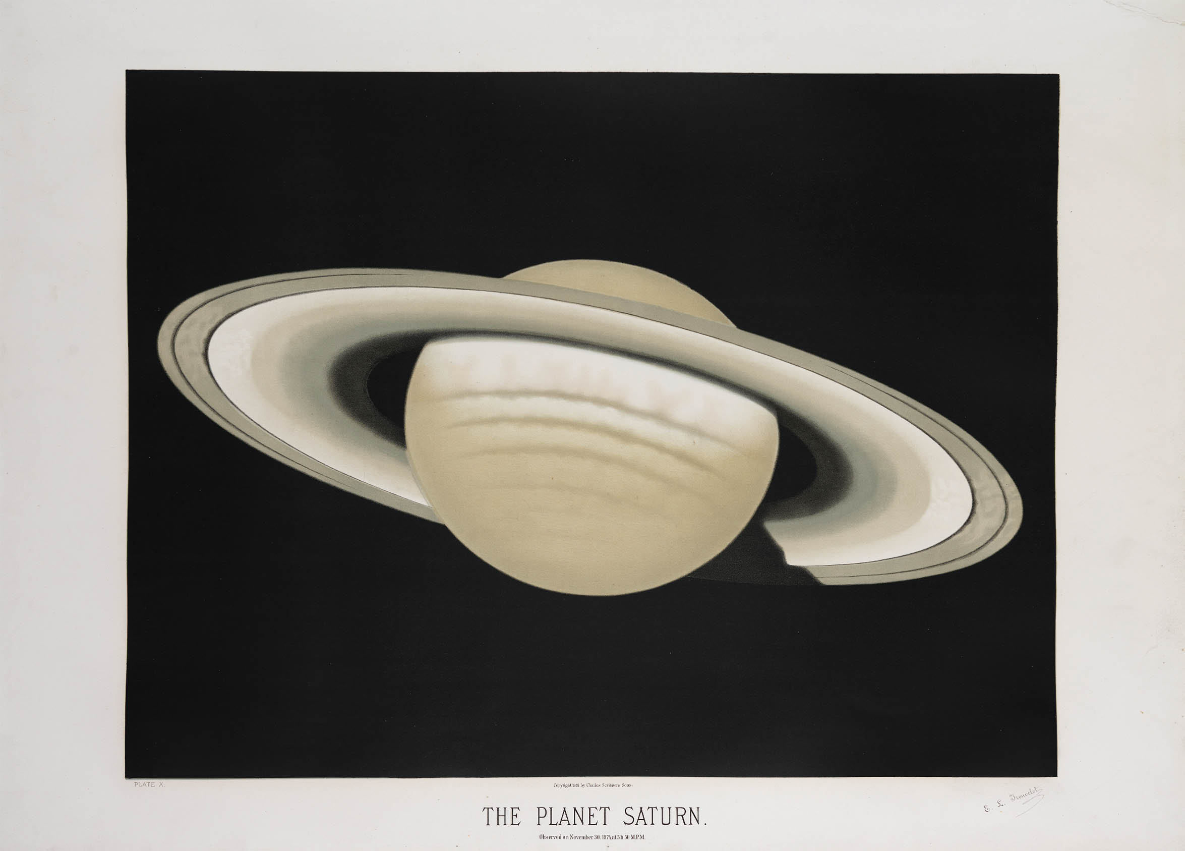
And here are the rest of the plates:


Total Eclipse of the Sun, click for larger image
The Zodiacal Light, click for larger image
Mare Humorum, click for larger image
Partial Eclipse of the Moon, click for larger image
The Planet Mars, click for larger image
The The Planet Jupiter, click for larger image
The Planet Saturn, click for larger image
The Great Comet of 1881, click for larger image
The November Meteors, click for larger image
Part of the Milky Way, click for larger image
Star Clusters in Hercules, click for larger image
The Great Nebula in Orion, click for larger image

In 1882 Trouvelot accepted a position at the Meudon Observatory in Paris. He continued his astronomical research using their Grande Lunette and even travelled to the Caroline Islands to observe the total eclipse of 1883. He wrote that one day he hoped to return to America but he never did. He died in Meudon on 22 Apr 1895.

Trouvelot was a classic case of the Victorian autodidact. With no formal training he left behind a legacy of several books and monographs, more than 50 scientific papers and nearly 7000 illustrations covering the entire range of natural science – everything from astromony to moths and butterflies to reptiles to geological surveys. Of course he will be remembered for his other legacy – the gypsy moth – which continues to spread across North America and causes nearly a billion USD of damage each year.

1. Unless otherwise noted, all of the images here are from the Public Library of Cincinnati

2. For more bibliography see: Spear, Robert. The Great Gypsy Moth War: The History of the First Campaign in Massachusetts. Amherst: University of Massachusetts Press, 2005 (WorldCat) or Corbin, B.G. Etienne Leopold Trouvelot (1827–1895), the Artist and Astronomer. Library and Information Services in Astronomy V, ASP Conference Series. 2007 377: 352– 360 (online).

3. See: Trouvelot, L. The American Silk Worm. American Naturalist 1867; 1(1) 30-38 (online).

4. Bond, W. C., Bond, G. P., Winlock, J. Annals of the Astronomical Observatory of Harvard College. Cambridge: John Wilson and Son, 1876 (online).

5. Trouvelot, E. L. The Trouvelot Astronomical Drawings. New York: C. Scribner's Sons, 1882 (WorldCat).

6. Adjusted for inflation that’s more than 3000 USD today. However, according to the Publications of the Astronomical Society of the Pacific, Scribners was remaindering copies for only 10 USD in 1886.

Friday, December 18, 2015

A Book of Unexplained Facts (Last Place on Earth)

Carte des Terres Australes, click for larger image
Detail, Carte des Terres Australes, 1739. BNF

The Last Place on Earth

Bouvet Island

In Oddities, A Book of Unexplained Facts Rupert Gould wrote:

“Around Bouvet Island, it is possible to draw a circle of one thousand miles radius (having an area of 3,146,000 square miles, or very nearly that of Europe) which contains no other land whatever. No other point of land on the earth’s surface has this peculiarity.” 
Indeed, the tiny uninhabited island – a glacier-covered volcanic shield lying at the far southern end of the Mid-Atlantic Ridge – is literally the most remote place on Earth. Perhaps then it’s no wonder that it proved so elusive to 18th and 19th century polar explorers.

Rupert Thomas Gould (16 November 1890 – 5 October 1948), was a lieutenant commander in the British Royal Navy noted for his contributions to horology (the science and study of timekeeping devices). He was also an author and television personality.

Gould grew up in Southsea, near Portsmouth, where his father, William Monk Gould, was a music teacher, organist, and composer. He was educated at Eastman's Royal Naval Academy[1] and then, from 15 January 1906 on, he attended the Royal Naval College, Osborne, and then the Royal Naval College, Dartmouth, being part of the 'Greynville' term (group), and by Easter 1907, examinations placed him at the top of his class. He became a midshipman, and thereby a naval officer, on 15 May 1907. He initially served on HMS Formidable and HMS Queen (under Captain David Beatty) in the Mediterranean. Subsequently he was posted to China (first aboard HMS Kinsha and then HMS Bramble). He chose the "navigation" career track and, after qualifying as a navigation officer, served on HMS King George V, and HMS Achates until near the outbreak of World War I, at which time he suffered a nervous breakdown and went on medical leave. During his lengthy recuperation, he was stationed at the Hydrographer's Department at the Admiralty, where he became an expert on various aspects of naval history, cartography, and expeditions of the polar regions. In 1919 he was promoted to Lieutenant-Commander (retired).
On 9 June 1917 he married Muriel Estall. That marriage ended by judicial separation in November 1927. They had two children, Cecil (born in 1918) and Jocelyne (born in 1920). His last years were spent at Barford St Martin near Salisbury, where he used his horological skills to repair and restore the defunct clock in the church tower.

Jean-Baptiste Charles Bouvet de Lozier was educated in Paris then studied navigation at St. Milo. He joined the French East India Company and by 1731 had reached the rank of lieutenant. At the young age of 30 he petitioned his employers with a plan for an “exploratory mission” of the southern seas for land that could accommodate French trading vessels on route to the Far East.

On 19 Jul 1738, outfitted with the Aigle and Marie he set sail for Brazil. After repairs and provisioning on Santa Catarina Island he sailed south, crossing the 44th parallel in early December. By the end of the month the expedition was some 1600 miles from inhabited land sailing in increasingly difficult, uncharted polar waters.

At 3:00 pm on New Years Day, 1739 he spotted “a very high land, covered with snow, which appeared through the mist.” He spent 12 days attempting to harbor but found that conditions made it impossible. With his crew nearly freezing to death and suffering from scurvy he was forced to turn north, eventually reaching the Cape of Good Hope on Feb 24. Bouvet was convinced that the land he found was a promontory of the fabled Terra Australis and named it Cap de la Circoncision (Cape of Circumcision). It was, according to his calculations, 54°S, 11°E, making it the southernmost point of land ever sighted. 

The map of his voyage (above) prepared by Philippe Buache, a leading polar theorist, became immediately influential, adding to the scant cartographic knowledge below the 50th parallel. In 1754 Buache prepared a second edition of the map showing the Cape of Circumcision attached to his fanciful rendition of Terres Antartiques:


Carte des Terres Australes, click for larger image
Carte des Terres Australes, 1754. BNF


Accurate reckoning of longitude was the fundamental problem of 18th century navigation and Bouvet’s calculations placed his discovery considerably too far east. James Cook, on the Antarctic leg of his 1772 and 1776 expeditions, attempted locate Bouvet’s Cape with no success.

The Cape was next sighted in 1808 by James Lindsay, captain of the British whaler Snow Swan. He, too, was unable to land, although he did recognize the promotory as an island which he circumnavigated and named after himself – Lindsay Island. The first landing occured in 1822 by the American Benjamin Morrell aboard the seal hunting ship Wasp. Morell named it Bouvettes Island, in honor of its discoverer. Three years later George Norris, master of the British whaler Sprightly, landed on the island, claimed it for the British Crown and named it Liverpool Island.

Then the island simply disappeared. Subsequent explorers, such as James Clark Ross in 1843 or Thomas Moore in 1845, all failed to again locate it. As Boudewijn Büch famously wrote “[they] knew it existed, but that’s all [they] knew."

The island was rediscovered by the marine biologist Carl Chun during his 1898 German Deep-Sea Expedition aboard the steamer Valdivia. On 3 Nov 1898, at the exact same time of day Bouvet recorded his sighting 159 years earlier, he spotted the island and made the first accurate calculations of its size (19 mi2) and position (54°26'4"S. 03°24'2"E). The accounts of the expedition included the first photographs and map:


Bouvet Island, click for larger image
Bouvet Island, southeast side, as seen at sunrise, eight miles distant, Nov 26, 1898. 


Bouvet Island, click for larger image
Bouvet Island, south side Nov 26, 1898


Bouvet-Insel, click for larger image
Bouvet-Insel
 
Although remote and inhospitable, Bouvet was still of interest to 20th century whalers. The Norwegian entrepreneur Lars Christensen identified the island as a potential site for a whaling station and in 1927 sent his research vessel Norvegia to investigate. Although the island, with its nearly vertical cliffs, was a poor choice for a station, the crew under captain Harald Hornvelt landed on Bouvet, built a hut (the Villa Haapløs), and claimed the island for King Haakon VII. Despite British objections, this claim has stood.


Depot at Cape Circoncision on Bouvet Island, 1927. Norsk Polarhistorie


Here is the expedition’s map of the island:

Bouvet-Insel, click for larger image
Bouvet-Insel, 1927


Since the Norwegian annexation the island has been visited sporadically by scientific expeditions. For the International Geophysical Year and again in the 1960s the Royal South African Navy conducted meteorological expeditions. They performed the first true surveys and the RSA Hydrographic Office produced a map in 1955 and a bathymetric chart in 1967. For two decades these were the best maps of the island available. Here is a sadly 2-bit version of the 1955 map:


Bouvet Island, click for larger image
Bouvet Island, 1955. From ref. 6


The 1977/78 Norwegian Antarctic Research Expedition performed a completely new survey, including helicopter photogrammetry, doppler satellite geodesy and echo sounder hydrography. Their maps, although the most detailed to date, were nevertheless incomplete; constant low cloud cover prevented mapping of the eastern slope of the island. In his description of the map Sigurd Helle wrote “A future, more complete surveying may indeed give a new map which may deviate from the enclosed.”


Bouvetoya 1:20 000, click for larger image
Bouvetøya 1:20 000, 1981


Bouvetoya 1:60 000, click for larger image
Bouvetøya 1:60 000, 1981.


The 1985/86 Norwegian expedition, blessed with a unusual period of cloudless weather, was able to photograph the entire island, establish new control points and complete the earlier surveys.8 Their new topographical map was published in 1986 and updated several times. It may very well be the last great paper map of the island 


Bouvetoya 1:20 000, click for larger image
Bouvetøya 1:20 000, 2000. Norsk Polarinstitutt


Today, in an era of high-res remote sensing, no place is truly too remote – its all just a satellite photo away:


Bouvet Island, click for larger image

Bouvet Island from the ISS, 13 Sep 2008. NASA


Bouvet Island, click for larger image
Bouvet Island from Landsat 8, 26 May 2013. NASA


1. Gold, Rupert. “The Auroras, and Other Doubtful Islands” in Oddities, A Book of Unexplained Facts. London: Philip Allan & Co., 1928 (WorldCat).
2. Bouvet named his newly-discovered cape after the 1 Jan Catholic Feast of the Circumcision.
3. See: Büch, Boudewijn. Eilanden. Amsterdam: De Arbeiderspers, 1991 (WorldCat).
4. Chun, Carl. Aus den Tiefen des Weltmeeres: Schilderungen von der Deutschen Tiefsee-expedition. Berlin: Gustav Fischer, 1903 (online).
5. Die Deutsche Tiefsee-Expedition auf dem Schiff “Valdivia,” 1898/1899: Nach Amtlichen Berichten. Berlin: 1899 (online).
6. Burdecki, Felix. Errichtung einer Wetterstation auf Bouvet Oya? Polarforschung. 1965 35 (1/2): 38–41 (online).
7. Bouvetøya, South Atlantic Ocean: Results from the Norwegian Antarctic Research Expeditions 1976/77 and 1978/79. Skrifter 175. Oslo: Norsk Polarinstitutt, 1981 (online).
8. Report of the Norwegian Antarctic Research Expedition (NARE) 1984/85. Rapportserien 22. Oslo: Norsk Polarinstitutt, 1985 (online).

Wednesday, December 16, 2015

Buen humor, 19th C.


Buen humor was a spanish satiric magazine published during 1920's. These scans come all from the sprawling Hemeroteca Digital database of the National Library of Spain. Graphic artist and cartoonist Pedro Antonio Villahermosa y Borao (nicknamed Sileno) founded Buen Humor in 1921. It ran for 400 or 500 issues (Hermeroteca houses 410) until 1931. You can read more about it (in Spanish) here. Also here.

Other illustrators who worked on Buen Humor were: Rafael de Penagos (1889-1954), Lluis Bagaria Bou (1882-1940), Ricardo García López (1890-1984) aka K-Hito, Francisco López Rubio (1895-1965), and Salvador Bartolozzi.