Sunday, January 8, 2012

Mayan drawings from Palenque (18th Century)

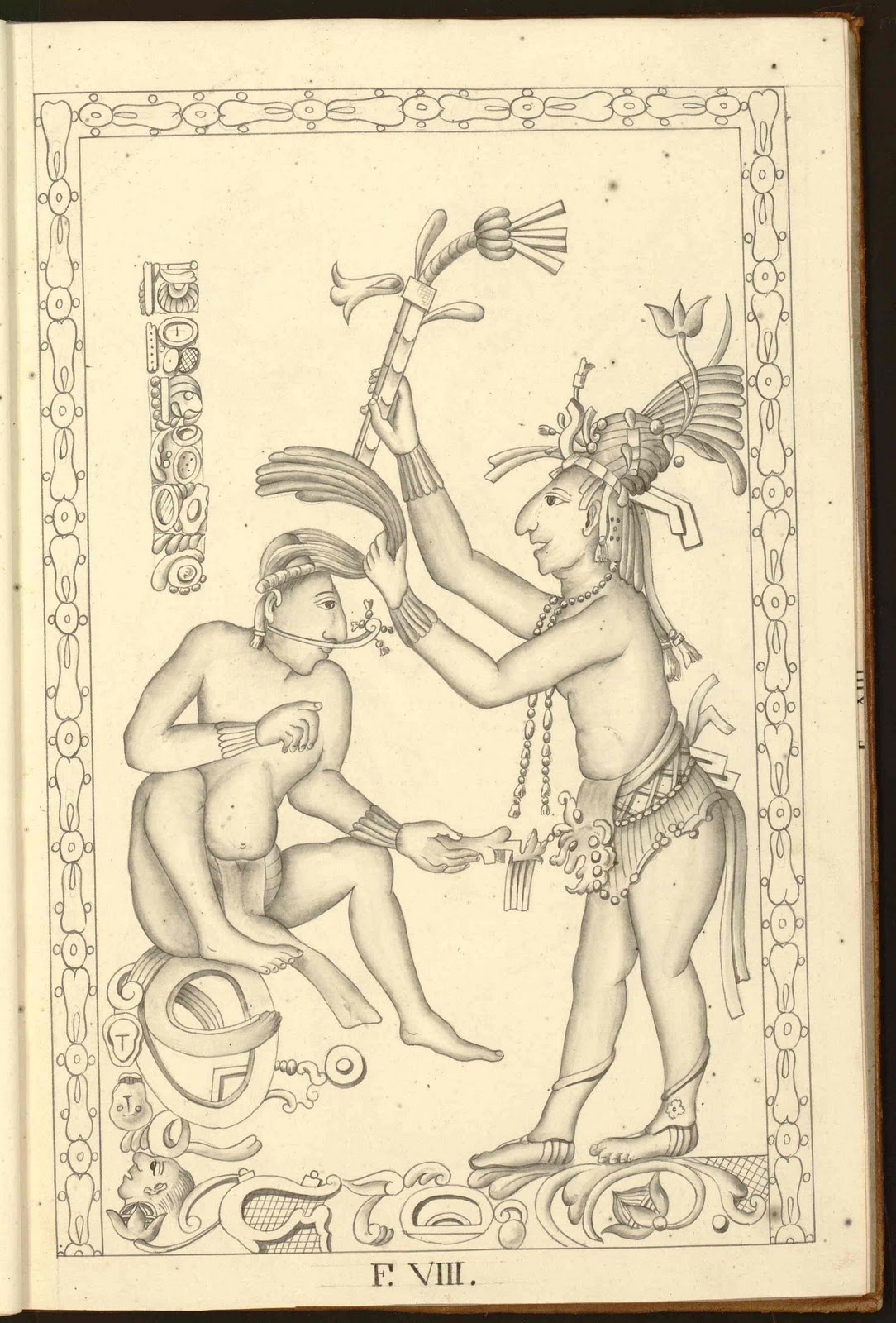
Stucco relief at Palenque, appears on the exterior face of Pier E in House A, part of the central complex of buildings known as the Maya Palace. See below photo to see this same relief nowadays.
The reason why this drawings remain scientifically useful. Photo taken in 2008. Reliefs are lost due to ambient exposure.
Antonio del Río (1745-1789) was a Spanish Captain assigned to the american administrative division in Spanish Imperium which covered much of Central America (including what are now the nations of Costa Rica, Nicaragua, Honduras, El Salvador and Guatemala, and the Mexican state of Chiapas). Del Rio led the first “archaeological exploration” in the Americas. Undertaken in only two months (May-June, 1787), this expedition was performed under direct command of King Carlos III of Spain and originally oriented to investigate the Mayan complex of buildings located in Santo Domingo de Palenque (Ciudad Real de Chiapas, formerly Reyno de Guatemala), known as “the Mayan Palace”.
Antonio del Rio and his expedition spent around 2-3 weeks digging on site and then 4-5 weeks studying and documenting all findings. They made a complete report with around thirty drawings, remarkably accurate, that shows detail of all buildings and bas reliefs that have been lost due to ambient exposure since then. Del Río's manuscript has been preserved in the Museum of Americas in Madrid, Spain, but the drawings were only recently found in a private European collection.


Sunday, January 1, 2012

De re militari (15th Century)

Armored ship

Roberto Valturio (Rimini, Italy, 1405-1475), author, dedicated this military treatise to his Patron and Condottiero, Sigismondo Pandolfo Malatesta - popularly known as the “Wolf of Rimini”- and considered by his contemporaries as one of the most daring military leaders in Italy. Malatesta commanded Venetia military forces against the Ottonian Imperium. When the treatise was finished by Valturio, around 1465, Malatesta distributed copies to European and relevant rulers like Louis XI, Francesco Sforza, Lorenzo de Medici, etc. The codex served as compilation for war recommendable strategies, some of them really new and ingenious, like a draft for a four propellers submarine boat (first submarine designs were engineered more than 200 years later) or an inflatable device to avoid a soldier get sink when crossing defensive inundated pits. Valturio’s submarine proposal, on 15th Century, was probably the most striking drawing of this fascinating codex for me.
Only twenty-two handwritten copies survive to our days. Leonardo da Vinci was the owner of one manuscript, and based some of his drawings about military technology on this codex.

Over wheels attack "dragon-tower" equiped with canyons, based on trojan horse design

Combat wagon

four propeller submarine boat designed by Roberto Valturio


inflatable device to avoid a soldier get sink when crossing defensive inundated pits
 

Sunday, December 25, 2011

Cosmographia Claudii Ptolomaei Alexandrini (15th Century)

Introduction to Europe Maps, part I: Ireland (Ibernie Insvle) and Great Britain (Albionis Insvle).

This cosmography was commissioned by Nicolaus Germanus in 1465 and dedicated to the Pope Paul II. Nicolaus Germanus (1420-1490) was a german cartographer, who lived temporally as a monk of Benedictine order, possibly on the Reichenbach Monastery, and later on a Benedictine Monastery close to Florencia, Italy ¿?. His works were of great value in diffusing the knowledges of Ptolemy's Geography. Apart of this Cosmography, I know that in Modena (Italy), the Bibliotheca Estensis has another latin translation of the Geography of Ptolemy, probably still not digitized. Another cosmography is also hosted at Lenox Library in New York. The most important characteristic of this Cosmography is that Nicolaus, instead of adhering to the flat projection of Ptolemy, chose what is known as the “Donis” projection system, that he invented, in which the parallels of latitude are equidistant, but meridians are made to converge towards the pole. This projection system is also known as “trapezoid projection”. Another interesting characteristic in this compilation is the introduction of updated maps for Spain, Italy and the Northern countries. 

Spain and Portugal. Nicolaus updated the official map for Spain with high detail (main cities and towns)